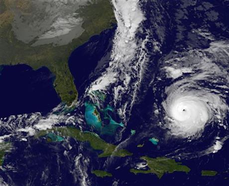

HAMILTON, Bermuda (AP) — Hurricane Gonzalo churned toward Bermuda as a dangerous Category 4 storm early Thursday, gaining new strength over the open Atlantic as the small British territory rushed final preparations.
The U.S. National Hurricane Center in Miami said Gonzalo reached Category 4 strength during the night. It was briefly a Category 4 storm on Wednesday before dropping some punch for several hours and then gaining new strength. Forecasters said fluctuations in intensity are normal for hurricanes.
Early Thursday, Gonzalo packed top sustained winds of 140 mph (220 kph) with higher gusts and was centered about 540 miles (865 kilometers) south-southwest of Bermuda. It was moving toward the north at 9 mph (15 kph) toward Bermuda, where a hurricane warning remains in effect.
The hurricane center said early Thursday that the eye of Gonzalo was forecast to pass near Bermuda sometime Friday. It added “Gonzalo is expected to be a dangerous hurricane when it moves near Bermuda” even though slow weakening was in the forecast for the storm on Thursday night and Friday.
Forecasters said a dangerous storm surge accompanied by large, destructive waves could cause significant flooding on the island, which has some 64 miles (103 kilometers) of shoreline and has an area about one-third the size of Washington, D.C. Some 3 to 6 inches (8 to 15 centimeters) of rain was predicted.
The government said it would close the island’s international airport Thursday night, when tropical storm conditions were first expected. Several airlines increased the number of flights departing from Bermuda ahead of the storm.
Bermuda’s residents already were coping with the aftermath of Sunday’s Tropical Storm Fay.
More than 1,000 homes remained without power and homeowners worked to repair damaged roofs. The government called out 200 soldiers of the Bermuda Regiment to help with cleanup efforts on the island of roughly 70,000 people.
On Wednesday, people stripped the island’s hardware stores of generators, batteries, candles and other items and picked up free tarpaulins distributed by the government. Supermarkets and gas stations braced for more crowds Thursday.
Bermuda, which is 850 miles (1,400 kilometers) east of the U.S. state of South Carolina, has one of the highest per-capita incomes in the world and its strict building codes make structures particularly capable of withstanding storms.
Gonzalo swept by the eastern Caribbean earlier this week, claiming at least one life in the Dutch territory of St. Maarten. Two people were missing, one in St. Martin and the other in St. Barts.
___
Associated Press writer Danica Coto in San Juan, Puerto Rico, contributed to this report.
