

From Media Reports
OCEAN SPRINGS – With the threat of Isaac looming overhead, city officials on Mississippi’s Gulf Coast are preparing for the worst.
Governor Phil Bryant has already declared a state of emergency as residents in Pascagoula, Biloxi, Ocean Springs, Gulfport and others are stocking up on supplies.
“While the track of the storm may change, Mississippians need to make preparations now,” Bryant said. “I urge Mississippians to heed all warnings and evacuation orders by local and state officials.”
 The governor also authorized the Mississippi National Guard to deploy 10 people to the Coast. Robert Latham, director of the state’s emergency management agency said the emergency response team was sent to the Coast on Sunday. The team includes representatives from various state departments and MEMA.
Isaac made a big shift to the west Saturday night/Sunday morning, putting Mississippi and Louisiana directly in its path. Forecasters say that movement may continue.
“Models are continuing to favor a more westerly track at this point,” WLOX Chief Meteorologist Mike Reader said. “As the storm gets better organized, confidence in what the models are predicting is higher.”
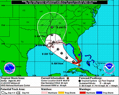
By Sunday, Tropical Storm Isaac’s projected path had changed again, according to the National Weather Service’s latest report.
“People need to know if they live in a low-lying area,” said Rupert Lacy, director of the Harrison County EMA. “If they do, they need to move to higher ground. ”
Shelters in Jackson County will open at 4 p.m. Monday August 27.
“This is a major storm, and we have to be very prudent about decision making,” Lacy said. “But we don’t want people to be in shelters if they don’t need to be.”
The following locations will be used as storm shelters in Jackson County: East Central High School, St. Martin High School and Vancleave High School. A Special Needs shelter will be located at the East Central Community Center on Hwy 614.
The Mississippi Gulf Coast is currently at the center of the projection cone and Isaac has maintained speed and taken a WNW turn as the storm moves along Cuba and heads toward the Florida Panhandle, according to the National Weather Service’s 10 a.m. report.
Isaac’s maximum sustained winds are at 65 mph and is moving WNW at 18 mph.
The Florida Panhandle as well as southern coastal Florida remain under hurricane warning. Isaac is expected to strengthen to a hurricane and take a more westward turn once entering the Gulf of Mexico, and is expected to make landfall somewhere between the Louisiana and Alabama coastline early Wednesday morning.
Several cities along the Coast declared states of emergency Sunday, and Long Beach ordered boats and other vessels south of U.S. 90 to be removed from the city’s harbor.
Mayor Billy Skellie also recommended residents in low-lying areas south of the railroad tracks leave their homes.
Some cities and counties along the Coast provided sand and bags for residents.
Weather officials said late Sunday, Isaac was having trouble developing, but meteorologists expect it to reach hurricane strength sometime Monday and make landfall either late Tuesday or early Wednesday, the seventh anniversary of Hurricane Katrina.
Forecasters warn that no matter where Isaac makes landfall, residents along the Gulf Coast will see heavy rain, wind and storm surge as Isaac is about 800 miles wide.
The National Hurricane Center issued a hurricane warning Sunday afternoon from Morgan City, La., to Destin, Fla.
A tropical storm is considered a hurricane when it reaches maximum sustained winds of 74 mph, and officials believe the storm could reach hurricane strength later Sunday, becoming a Category 1 or Category 2 hurricane before landfall.
A Category 1 storm has winds of 74-95 mph. A Category 2 storm has winds of 96-110 mph.
The next 12 to 24 hours will be a critical time for watching where Isaac appears to be heading, Lacy said. “Within the next day, we will get a better idea of where it decides to make its presence known,” he said. “We’re not out of the woods yet, but people who have not started making plans should seriously think about it now.”
That includes plans for possible evacuation, gathering emergency food and water supplies and securing loose property outdoors that could become a flying projectile.
With hurricane models showing the projected path turning a bit west, South Mississippi residents need to take the possibility of landfall here seriously, Lacy said.
“It’s a beautiful day, and it’s a great time to go ahead and make preparations. Don’t let your guard down. If it starts to turn crappy, so be it. We will move forward with whatever we have to deal with.”
The National Weather Service in New Orleans issued a flood warning Sunday for the Tchoutacabouffa and Wolf rivers. The flood stage for each is 8 feet, but both are expected to crest at 9.5 feet Wednesday.


Be the first to comment